We crossed the border and the heavens open with full force for a few days, we decided to ride into Quito, and stock up with a few things and met up with @CourtRand at Freedom and had a chat about possible routes…these guys know Ecuador better than anyone. We had a rough idea of where we wanted to ride to try and create an offroad route from border to border and Court made a few tweaks with some of his favorite roads.
![[IMG]](https://photos.smugmug.com/photos/i-ggkzL8j/0/0aa7e0f8/X2/i-ggkzL8j-X2.jpg)
New route in hand we headed back north, jumped on our first dirt road and at 4000m in the rain, a flat!
![[IMG]](https://photos.smugmug.com/photos/i-MNgbH5N/0/90fc599a/X2/i-MNgbH5N-X2.jpg)
The rain continued and we headed for much lower ground trying to find a little warmth and in the process missed our turn off, but it would have taken us back to 4000m and more rain, we figured tomorrow!
The following morning we looked at a map and thought we’d spotted a shortcut, maybe some single track for 20-30k but hey let’s go have a look, the dirt road in was good
![[IMG]](https://photos.smugmug.com/photos/i-S925xHG/0/1d29260b/X2/i-S925xHG-X2.jpg)
right until we reached this point, I jumped off the bike, walked on to the soaking wet bridge and the wood was rotten and cracking under my weight so didn’t want to risk putting a bike on there with a 50-foot drop to a river below
![[IMG]](https://photos.smugmug.com/photos/i-FjPfmkZ/0/ffdb82e3/X2/i-FjPfmkZ-X2.jpg)
Everybody’s favorite, backtracking and we made it to the entrance of the Cayambe Coca Ecological Reserve, this area has restricted vehicle access but Court had given us a special permit so we could ride thru, sadly, we ended up in fog and clouds and didn’t see much past about 100m…its supposed to be spectacular
![[IMG]](https://photos.smugmug.com/photos/i-WCnZnLk/0/5da650a4/X2/i-WCnZnLk-X2.jpg)
Standing up to see over the trees when the valley cleared for a few seconds
![[IMG]](https://photos.smugmug.com/photos/i-nx7ZSK3/0/e30bb545/X2/i-nx7ZSK3-X2.jpg)
![[IMG]](https://photos.smugmug.com/photos/i-m3DQ8Z3/0/53dae2b0/X2/i-m3DQ8Z3-X2.jpg)
Eventually, we clear the Reserve ending up in a little town that was long past it prime, we rode thru many of the same, some were a little tighter to get thru than expected but it kept us on dirt
![[IMG]](https://photos.smugmug.com/photos/i-nZm6gVq/0/b3342931/X2/i-nZm6gVq-X2.jpg)
![[IMG]](https://photos.smugmug.com/photos/i-VsbJ5JJ/0/39e23689/X2/i-VsbJ5JJ-X2.jpg)
you can’t come to Ecuador without doing the tourist stop at the Equator, even though our track had us cross it about 10 times already, this is a given
![[IMG]](https://photos.smugmug.com/photos/i-Rh4qSdZ/0/e9253b49/X2/i-Rh4qSdZ-X2.jpg)
![[IMG]](https://photos.smugmug.com/photos/i-wWSRGQT/0/65e9c08d/X2/i-wWSRGQT-X2.jpg)
The plan after the middle of the earth shot, was to take the next left and go to the Hacienda I had stayed at back in 2011, we got there, the doors were open, actually everything was open but no-one was around so we took off and headed to Cotacachi about 45km away.
@CourtRand had told us about a family we needed to meet – the following is what Egle wrote they may be more detail in her upcoming book –
****Luis and his father are the last natural leather tanners in Cotacachi, Ecuador. They use the huarango tree seeds to tan leather, as opposed to chemicals; it takes 24 hours to tan a hide using chemical processing whereas the natural huarango seed method takes a whole month. “All good things require time and patience”, – Luis explained, and it’s hard to disagree: he and his family seemed to have embraced a very special Andean zen and found happiness working together.
![[IMG]](https://photos.smugmug.com/Unlisted/n-dsjV2G/RTW-on-dirt-2018/2018-Ecuador-2/i-gHbxNnR/0/30554a0d/X2/S%20cotacachi%20leather-8-X2.jpg)
![[IMG]](https://photos.smugmug.com/Unlisted/n-dsjV2G/RTW-on-dirt-2018/2018-Ecuador-2/i-v8qf6cM/0/4448ed8d/X2/S%20cotacachi%20leather-15-X2.jpg)
![[IMG]](https://photos.smugmug.com/Unlisted/n-dsjV2G/RTW-on-dirt-2018/2018-Ecuador-2/i-F6qn3Rh/0/bfcfbb53/X2/S%20cotacachi%20leather-18-X2.jpg)
![[IMG]](https://photos.smugmug.com/Unlisted/n-dsjV2G/RTW-on-dirt-2018/2018-Ecuador-2/i-cLNCDP8/0/0fdbe26e/X2/S%20cotacachi%20leather-20-X2.jpg)
Luis’ mother Maria – a woman with a thousand smiles – offered us some homemade chicha, a local corn and grain flour drink that is cooked and steeped overnight. “You’ll live a hundred and ten years if you drink this instead of Coca-Cola and beer!”, – Luis’ dad declared.
![[IMG]](https://photos.smugmug.com/Unlisted/n-dsjV2G/RTW-on-dirt-2018/2018-Ecuador-2/i-XqVzxJ8/0/d90255b0/X2/S%20cotacachi%20leather-51-X2.jpg)
![[IMG]](https://photos.smugmug.com/Unlisted/n-dsjV2G/RTW-on-dirt-2018/2018-Ecuador-2/i-QHwQ23P/0/ddb9f3b2/X2/S%20cotacachi%20leather-49-X2.jpg)
![[IMG]](https://photos.smugmug.com/Unlisted/n-dsjV2G/RTW-on-dirt-2018/2018-Ecuador-2/i-LxvsmJt/0/a030785b/X3/S%20cotacachi%20leather-78-X3.jpg)
We talked a lot about tanning leather, making drums from llama skins and growing long hair – something that’s very special to the local indigenous people of the Andes. “Long hair is part of our identity. Not too long ago, my mestizo co-workers in Otavalo would make fun of me telling me I was wearing my “tie backward”, referring to my braid. Or they’d say I should cut it because I looked like a woman. But it’s part of who we are”, – Luis explained.
![[IMG]](https://photos.smugmug.com/Unlisted/n-dsjV2G/RTW-on-dirt-2018/2018-Ecuador-2/i-qBZKVV5/0/fd26671d/X2/S%20cotacachi%20leather-39-X2.jpg)
Luis’s father is very proud of this python skin brought to him by a friend from the Amazon. He’s been planning to make boots and bags from it for a while now, but just can’t bring himself to cut this beautiful skin up.
![[IMG]](https://photos.smugmug.com/Unlisted/n-dsjV2G/RTW-on-dirt-2018/2018-Ecuador-2/i-22vm6s9/0/700756a3/X2/S%20cotacachi%20leather-56-X2.jpg)
![[IMG]](https://photos.smugmug.com/Unlisted/n-dsjV2G/RTW-on-dirt-2018/2018-Ecuador-2/i-gBx7WCk/0/ee51b4bc/X3/S%20cotacachi%20leather-57-X3.jpg)
Working quietly in their little tannery in the outskirts of Cotacachi, the Yamberla family was so welcoming and friendly we stayed there for hours, just chatting and sipping chicha. Luis fixed my ripped pants by patching them up with this gorgeous handmade patch that he’d made then and there.
![[IMG]](https://photos.smugmug.com/Unlisted/n-dsjV2G/RTW-on-dirt-2018/2018-Ecuador-2/i-2Pn5Jh3/0/1fc2fdd0/X2/S%20cotacachi%20leather-47-X2.jpg)
When Luis’s father was a small child, a lot of indigenous people were still forced to work on big landowners’ farms for free or for a scrap of land for their own use. The feudal system is now gone – but not forgotten. “There still are very few indigenous people in power positions because in Ecuador, the belief that only whites can give orders and make important decisions still linger. We own our land now, though. All my sisters have small farms and grow corn, beans, and potatoes in the mountains”.
![[IMG]](https://photos.smugmug.com/Unlisted/n-dsjV2G/RTW-on-dirt-2018/2018-Ecuador-2/i-csxC564/0/79bb633c/X2/S%20cotacachi%20leather-79-X2.jpg)
“The life of a Quechua woman? Work, work, and more work”, – Maria said, when I asked her about a female perspective. “Girls get married when they’re eighteen and make babies. But they must also work, at home and on the land or in the market”. I told Maria my country had a woman president serving her second term. She paused a little and said, “yes, Ecuador should have a woman president, too. But girls just can’t afford universities”.
![[IMG]](https://photos.smugmug.com/Unlisted/n-dsjV2G/RTW-on-dirt-2018/2018-Ecuador-2/i-qGQWGJL/0/56b20053/X2/S%20cotacachi%20leather-72-X2.jpg)
“I don’t always know what I’m going to make. But I love making things that people need, things that get used” – Luis Yamberla
![[IMG]](https://photos.smugmug.com/Unlisted/n-dsjV2G/RTW-on-dirt-2018/2018-Ecuador-2/i-GWPjhfZ/0/75bb7e96/X2/S%20cotacachi%20leather-54-X2.jpg)
![[IMG]](https://photos.smugmug.com/Unlisted/n-dsjV2G/RTW-on-dirt-2018/2018-Ecuador-2/i-nhGSbSb/0/a7808ce3/X2/S%20cotacachi%20leather-42-X2.jpg)
![[IMG]](https://photos.smugmug.com/Unlisted/n-dsjV2G/RTW-on-dirt-2018/2018-Ecuador-2/i-dQ4H69p/0/2f7ef316/X2/S%20cotacachi%20leather-48-X2.jpg)
![[IMG]](https://photos.smugmug.com/Unlisted/n-dsjV2G/RTW-on-dirt-2018/2018-Ecuador-2/i-PqQWswj/0/6436a933/X3/S%20cotacachi%20leather-59-X3.jpg)
![[IMG]](https://photos.smugmug.com/Unlisted/n-dsjV2G/RTW-on-dirt-2018/2018-Ecuador-2/i-RfMXr2m/0/4f9d057c/X2/S%20cotacachi%20leather-43-X2.jpg)
![[IMG]](https://photos.smugmug.com/Unlisted/n-dsjV2G/RTW-on-dirt-2018/2018-Ecuador-2/i-9nJrX2d/0/91a93bd1/X3/S%20cotacachi%20leather-38-X3.jpg)
These are the huarango tree seeds that Luis and his father collect themselves, then boil for two hours to get a dark liquid. They then soak the hides in it for a month, converting them into leather.
![[IMG]](https://photos.smugmug.com/Unlisted/n-dsjV2G/RTW-on-dirt-2018/2018-Ecuador-2/i-h2GQPcN/0/00e40bd9/X2/S%20cotacachi%20leather-27-X2.jpg)
![[IMG]](https://photos.smugmug.com/Unlisted/n-dsjV2G/RTW-on-dirt-2018/2018-Ecuador-2/i-v6pjX29/0/c82963b0/X2/S%20cotacachi%20leather-10-X2.jpg)
*****
As we walked away probably the most inspiring thing, for me, was the hides leaning against the wall opposite their shop
![[IMG]](https://photos.smugmug.com/Unlisted/n-dsjV2G/RTW-on-dirt-2018/2018-Ecuador-2/i-fq9HjPJ/0/12b6e013/X2/S%20cotacachi%20leather-55-X2.jpg)
![[IMG]](https://photos.smugmug.com/Unlisted/n-dsjV2G/RTW-on-dirt-2018/2018-Ecuador-2/i-7WdTKcR/0/c4d49e9f/X2/S%20cotacachi%20leather-62-X2.jpg)
The irony here is that wall of the building without the roof is the old leather factory that used chemicals, its obviously now out of business for many years and Luis and his family are still going strong with traditional values…not chemicals.
Luis’ daughter snapped a quick photo for us before we left and of course, their dog photobombed us
![[IMG]](https://photos.smugmug.com/Unlisted/n-dsjV2G/RTW-on-dirt-2018/2018-Ecuador-2/i-3K7rT4M/0/50f222f8/X2/S%20cotacachi%20leather-83-X2.jpg)
Here’s a quick video of Maria brushing out the tangles and knots from a skin, we forgot to ask, most likely llama or sheep. We were with them for around 3-4 hours and virtually the whole time she was working on this, progress was very slow, but dedicated
The following day we left town, filed the tanks and headed into the mountains, looking back towards the volcano
![[IMG]](https://photos.smugmug.com/Unlisted/n-dsjV2G/RTW-on-dirt-2018/2018-Ecuador-2/i-q2tLDfV/0/bfbcc152/X2/Ecuador%20%232%20S-2-X2.jpg)
we carried on down the track but it had a partial landslide and massive water damage with axle deep ruts, basketball sized rocks, at almos the bottom there was a ditch that looked like it was about 4 meters deep so we deemed impassable.
We found a lucky option so we didn’t have to backtrack, a barbed wire gate to the right and a few km double track that quickly turned to single track, fully loaded bikes on a mix of dry and muddy single track is always a fun ride, the single track here is just like at home and we’re more than used to riding it when needed, we hate having to backtrack
![[IMG]](https://photos.smugmug.com/Unlisted/n-dsjV2G/RTW-on-dirt-2018/2018-Ecuador-2/i-6b8q9VB/0/32fc49a3/X2/Ecuador%20%232%20S-6-X2.jpg)
![[IMG]](https://photos.smugmug.com/Unlisted/n-dsjV2G/RTW-on-dirt-2018/2018-Ecuador-2/i-K7mgJgx/0/2af66de1/X2/Ecuador%20%232%20S-10-X2.jpg)
![[IMG]](https://photos.smugmug.com/Unlisted/n-dsjV2G/RTW-on-dirt-2018/2018-Ecuador-2/i-R8TKQP8/0/fdd58b8a/X2/Ecuador%20%232%20S-19-X2.jpg)
We found an alternative route and headed upwards, the pass was at around 4200m, at 3800m both bikes died instantaneously with no apparent reason, we’d been to 4200m before with the current set up. They coughed and sputtered and didn’t want to climb any higher, we had no choice but to roll back down, as we’re rolling it dawned on me…bad gas!
A few hundred meters lower they ran, albeit badly, 1000m or further down they ran better
![[IMG]](https://photos.smugmug.com/Unlisted/n-dsjV2G/RTW-on-dirt-2018/2018-Ecuador-2/i-2FRCFP7/0/83a66d9e/X2/Ecuador%20%232%20S-20-X2.jpg)
we got to the bottom of this section of the track in the middle of nowhere there were two police pick up truck and four cops standing there closing a gate and locking it down. Five minutes later we would have been royally screwed. They let us pass telling us everything was good, they watched us go up and disappear into the distance but were intrigued why we came back down.
Bad gas, they all smiled and just said “yes!”
We took off to find a new gas station and fill back up and return to Cotacachi for another night.
We decided to get up early and head back to Colombia, the border area that is, not the country. A few km before the border there is a little town called Julio Andrade…hang a right, Clyde.
This takes you to a very spectacular road eventually, first, some great twisty pavement headed towards a tiny little Puebla called El Carmelo which doesn’t show on google maps unless you switch to satellite view.
About 1km before the Puebla there is a right turn guarded by the military. The reason is you are literally at the Colombian border and in an Ecuadorian red zone
The military was great, we told them we were headed east and they had no issues or concerns for our safety at all.
From here on out its a very simple dirt road a child on their first dirt bike could ride with zero issues, it starts in and out of a few minor outlying communities and fincas then the track joins the E10. At this point looking on a map you might think it would become paved…nope! The surface texture changed a little but that was about it, you are riding on the south side of a canyon and Colombia is to your left/ north
The road is just amazing, waterfalls on both sides, in 2 hours I counted 101 waterfalls!!!
![[IMG]](https://photos.smugmug.com/photos/i-QcTV2fv/0/c351ea16/X2/i-QcTV2fv-X2.jpg)
![[IMG]](https://photos.smugmug.com/photos/i-xpg4wkX/0/4971aa75/X3/i-xpg4wkX-X3.jpg)
The views, oh the views
![[IMG]](https://photos.smugmug.com/photos/i-jhSPG9h/0/42db015d/X2/i-jhSPG9h-X2.jpg)
![[IMG]](https://photos.smugmug.com/photos/i-3vVmvTW/0/394f79b0/X2/i-3vVmvTW-X2.jpg)
Egle has just significantly dropped the price of her Ecuador motorcycle tour in her Indiegogo campaign, so if you are looking at this and want to ride with us but think you don’t have the time this might be the deal for you, drop me a pm and I’ll give you the details, we’ll take you on all these crazy tracks we’ve found
![[IMG]](https://photos.smugmug.com/photos/i-vZJM2Fj/0/dba399ff/X2/i-vZJM2Fj-X2.jpg)
a few hours later you are looking out at the Amazon rainforest, a crazy fact I had to look up to confirm if it was true, before you hit the E45 going south – if you flew directly east it would be 13,000km before you hit the first major city and that would be Nairobi, Kenya…that a whole lot of trees and water in the middle!
we had our riding cut short when an oil tanker had flipped and spilled its load on the one and the only road headed south…just a little chaotic!
We rode the last 60km in the dark and the rain, we stopped at a little Hostel, owner offered a room for both of us for $15, looking at us soaking wet and dirty, he asked if wanted to unlimited use of his washer and dryer for an additional $5, and how about dinner for $3…we accepted all three.
We planned another day riding dirt but heavy rains made the rivers flow too high, and the mud too deep to make it fun on a loaded bike, so we continued riding towards a blue sky and hopefully a little more rideable track.
Right up to when we came across a roadblock.
![[IMG]](https://photos.smugmug.com/photos/i-XNmdwvT/0/24d48499/X2/i-XNmdwvT-X2.jpg)
The demonstration was about this particular area when most of Ecuador’s oil comes from, but the profits don’t stay, they get siphoned off and sent further south. This makes it the most dangerous area of Ecuador with the highest crime rate, we were told by the demonstrators and the worst roads.
The strange thing was as we rode towards it we were just talking about how good the paved roads were!
All we needed to do was make a left turn behind that second building on the left of the picture about 30 meters away, but they refused to let us thru. This is unusual as most of the time when a demonstration is reached and it’s obvious we aren’t locals we are let thru…not this time!
Egle even offered to interview them and do a write up for the press (in English) to make more people aware of their plight, they became rowdy and a little offensive towards her so she just walked away.
Cars and buses had been waiting 3 hours or more already when we arrived so we joined the wait.
The day drifted by and riding possibilities dwindled so we decided to ride pavement for a change and head to Banos, the second most visited place after Galapagos in Ecuador, riding thru small villages on a windy road that decreased in altitude so the order of the day went from dirt to ice cream sitting by a local bike shop
![[IMG]](https://photos.smugmug.com/photos/i-Q4s35pr/0/225bbefd/X2/i-Q4s35pr-X2.jpg)
We hung out in Baños for a few days just people watching and waiting for the rain to pass and just people watched, Baños is Ecuador’s Disney land, stores selling loads of plastic crap souvenirs and I ❤️ Baños t-shirts. If you sit there for long enough all you seem to notice is hats, lots and lots of hats. Ecuador is very famous for its hat, it called a Panama Hat!
The reason dates back to the construction of the 48-mile long Panama Canal that links the Pacific and Atlantic oceans. When construction commenced in 1881, most of the workforce was brought in from Ecuador who all wore their lightweight yet sturdy hats to shade themselves from the sun. As photos made their way across the globe of the work in progress, many started asking the question ‘Where can I get one of those Panama hats?’
Now there are a lot of variations, from the standard to more of narrow-brimmed trilby and also the more traditional indigenous versions and western styles, but most everyone has a hat
![[IMG]](https://photos.smugmug.com/photos/i-wPvrFNc/0/6e73d9a1/X2/i-wPvrFNc-X2.jpg)
![[IMG]](https://photos.smugmug.com/photos/i-CT7Rzzc/0/a5b88ea0/X3/i-CT7Rzzc-X3.jpg)
![[IMG]](https://photos.smugmug.com/photos/i-vd796Xq/0/14162df7/X3/i-vd796Xq-X3.jpg)
![[IMG]](https://photos.smugmug.com/photos/i-4vvBLMp/0/a89aad27/X2/i-4vvBLMp-X2.jpg)
![[IMG]](https://photos.smugmug.com/photos/i-RPTBzV2/0/5fa931bd/X2/i-RPTBzV2-X2.jpg)
![[IMG]](https://photos.smugmug.com/photos/i-DgXDPWN/0/71e5b664/X2/i-DgXDPWN-X2.jpg)
![[IMG]](https://photos.smugmug.com/photos/i-J7VCBR9/0/903b0e6e/X2/i-J7VCBR9-X2.jpg)
![[IMG]](https://photos.smugmug.com/photos/i-zJ7jD6C/0/2ef093c6/X2/i-zJ7jD6C-X2.jpg)
![[IMG]](https://photos.smugmug.com/photos/i-LkNGKrL/0/c5630f8d/X2/i-LkNGKrL-X2.jpg)
…but western culture is creeping in…
![[IMG]](https://photos.smugmug.com/photos/i-BBDZRCq/0/a24ec76c/X2/i-BBDZRCq-X2.jpg)
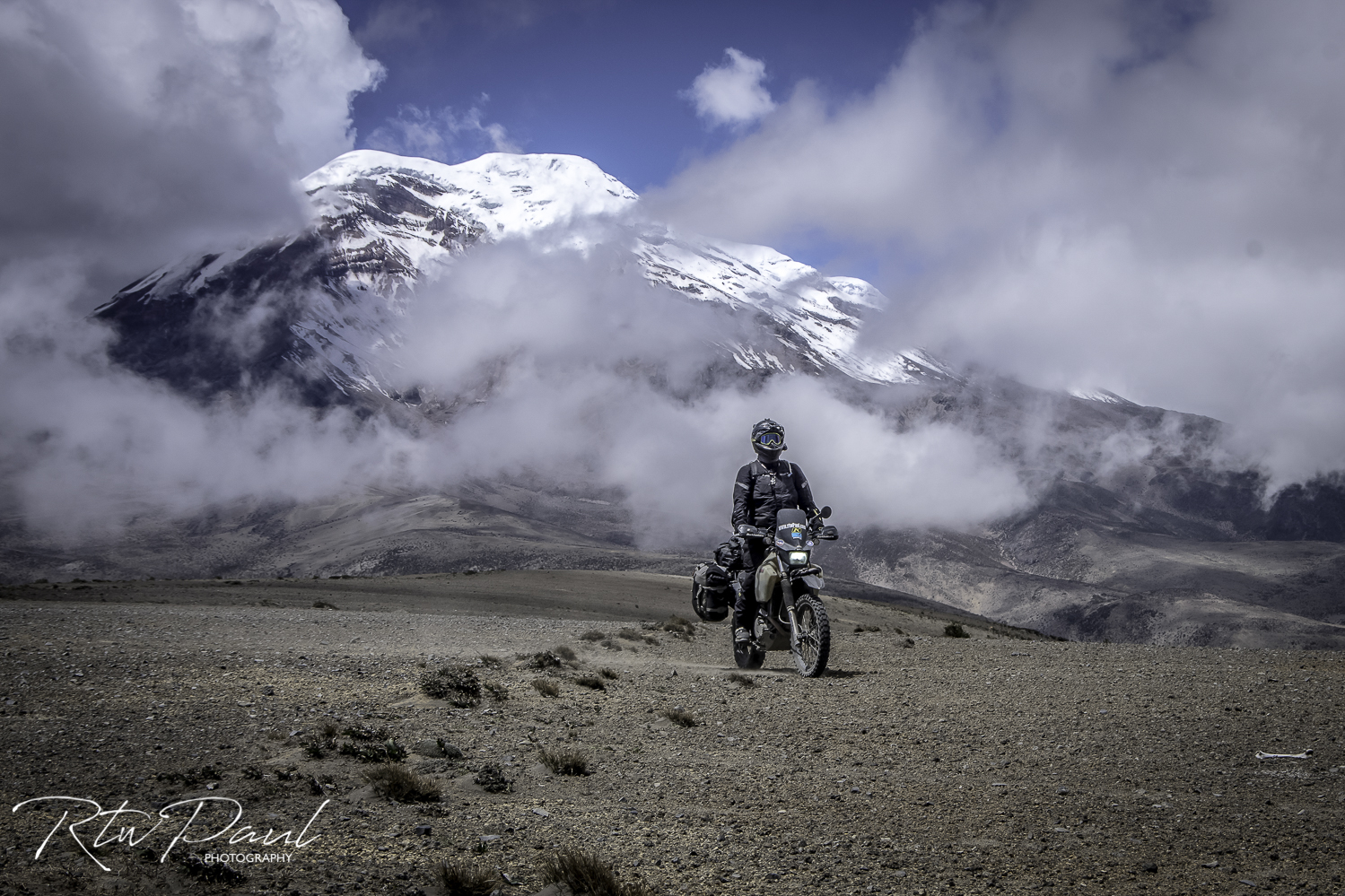
The weather showed the rain was due to stop so time to go up high, we had heard about a tiny little town in the mountains called Salinas de Guaranda and the nice thing about riding there was it was a mix of dirt and paved but it took us by the Chimborazo Volcano, Ecuador’s highest peak at 6263m/ 20,548′
![[IMG]](https://photos.smugmug.com/photos/i-gbn2tfT/0/293c8b3f/X2/i-gbn2tfT-X2.jpg)
Riding up to it, it was a sandy track to our left and volcanic rock to our right
![[IMG]](https://photos.smugmug.com/photos/i-m8nLVjp/0/fd073604/X2/i-m8nLVjp-X2.jpg)
![[IMG]](https://photos.smugmug.com/photos/i-TFdqH97/0/e861794d/X2/i-TFdqH97-X2.jpg)
![[IMG]](https://photos.smugmug.com/photos/i-pf6jhPJ/0/1ef7b46d/X2/i-pf6jhPJ-X2.jpg)
The track was at around 4300m and looking at the volcano it was like watching a time lapse, it would clear and cover in a 10-15 seconds and made it difficult to get a clear shot, high winds dropped the temperature down to the low 50’s/ high 40’s where that morning we’d been wearing shorts!
I hopped off the bike to take a clear shot of the bike and volcano and in the time it took me to walk this far away…missed it!
![[IMG]](https://photos.smugmug.com/photos/i-MFrLvdw/0/5fda9c36/X2/i-MFrLvdw-X2.jpg)
ride towards and it might clear
![[IMG]](https://photos.smugmug.com/photos/i-BPcx9w5/0/4e511bc0/X2/i-BPcx9w5-X2.jpg)
![[IMG]](https://photos.smugmug.com/photos/i-WXRBChM/0/3d2b2983/X2/i-WXRBChM-X2.jpg)
wait a while and there it is…
![[IMG]](https://photos.smugmug.com/photos/i-8LHd7ZS/0/3fdcb846/X2/i-8LHd7ZS-X2.jpg)
![[IMG]](https://photos.smugmug.com/photos/i-MJgc7D3/0/17cf161c/X2/i-MJgc7D3-X2.jpg)
Wiki told me – Chimborazo’s fun fact is that it’s not the highest mountain by elevation above sea level, but its location along the equatorial bulge makes its summit the farthest point on the Earth’s surface from the Earth’s center.
All we knew was that it was freezing and getting colder by the minute, all that was around at that altitude hanging out was us and Vicuñas, they can have it, we’ll come back on a warmer day to have another look.
![[IMG]](https://photos.smugmug.com/photos/i-6536bqv/0/03cf7570/X2/i-6536bqv-X2.jpg)

